Description
Finally, a map made by climbers for climbers
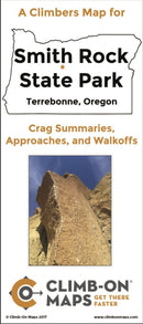
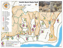
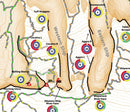
We go , not waste time! This is an indestructible, detailed rock climbing approach and trail map for Smith Rock, OR. This map complements Mountain Project and area guidebooks and picks up where they left off - the maps. There are labelled orientation photos, trail difficulty ratings, points of exposure, and the most comprehensive route data summaries for each climbing wall in the area (# routes, distribution of grades, and climb type). Plan your climbing day at a glance (distance/difficulty/type of climbing), find easier ways to get to a wall, avoid dead-end trails or trails that go nowhere, go to new areas you haven't yet explored. It is light and easy to use and carry, just toss it in your bag.
We go , not waste time! This is an indestructible, detailed rock climbing approach and trail map for Smith Rock, OR. This map complements Mountain Project and area guidebooks and picks up where they left off - the maps. There are labelled orientation photos, trail difficulty ratings, points of exposure, and the most comprehensive route data summaries for each climbing wall in the area (# routes, distribution of grades, and climb type). Plan your climbing day at a glance (distance/difficulty/type of climbing), find easier ways to get to a wall, avoid dead-end trails or trails that go nowhere, go to new areas you haven't yet explored. It is light and easy to use and carry, just toss it in your bag.
- 24" x 36" map (4" x 9" folded)
- Waterproof/tear-proof
- 2-sided
- overview map of all of Smith Rock State Park and adjacent BLM areas.
- Detailed insets (1:1,500)
- Alphabetized crag finder (using names found in Alan Watt's guidebook and Mountain Project)
- Approaches and walk-offs
- Trail difficulty ratings (easy, moderate, strenuous, ass kicker)
- Points of exposure (broken bones, major damage, Rest In Peace - RIP)
- Crag summaries (distribution of climb types, grades, number of multi-pitch and aid climbs)
- Walking-accessible top rope access noted
- Weight 54 grams
- Made in
- For more details visit climbonmaps.com.
You may also like
Recently viewed


